History of lake mburo national park
A Small Park With an Extraordinary Story
Tucked between the towns of Masaka and Mbarara in the Western Region of Uganda, Lake Mburo National Park may be the smallest savanna park in the country covering just 370 square kilometres but its story is one of the most layered, turbulent, and ultimately triumphant in African conservation history. Unlike many of Africa’s iconic wildlife sanctuaries that were carved cleanly out of wilderness, Lake Mburo emerged from the collision of ancient oral tradition, the ambitions of colonial administrators, the grievances of pastoral communities, the brutality of political upheaval, and finally the patient, difficult work of wildlife recovery and community reconciliation
To understand Lake Mburo National Park as it exists today a mosaic of acacia woodland, open savanna, glittering lakes, papyrus swamps, and rocky ridges, populated by zebras, impalas, buffaloes, elands, leopards, hippos, and over 350 species of birds you must trace a journey that stretches back hundreds of millions of years in geological time, thousands of years in human memory, and less than a century in formal recorded history. Every layer of that journey has left its mark on the landscape and the life that inhabits it.
The Ancient Foundations — Geology, Myth, and the Name “Mburo”
A Land Shaped by Deep Time
Long before any human culture knew this land, the ground beneath Lake Mburo was being shaped by forces that operated on geological timescales. The park is underlain by ancient Precambrian metamorphic rocks some of the oldest rock formations on the African continent dating back more than 500 million years. These rocks form the foundation of the rolling hills, rocky ridges, and sculpted outcrops that give the park its distinctive, undulating character. The Karagwe Ankolean system of rocks, a mixture of highly granitized and granitoid formations, alongside argillite rocks, arenites, and silty formations, defines the area’s terrain. The soils that developed over these ancient foundations are predominantly sandy and sandy clay loams fertile enough to attract pastoralists and farmers but not so deep as to invite dense forest, making the region naturally suited to savanna and grassland ecosystems.
The wetland system that forms the heart of the park five interconnected lakes joined by a network of swamps and papyrus channels is not a static feature. The lakes and their fringing vegetation have been changing continuously over geological and human time, shaped by rainfall patterns, tectonic movement, and the actions of the plants, animals, and people who have passed through this landscape across the centuries.
The Legend of the Two Brothers
Before geology comes legend, and it is legend specifically the oral tradition of the Bahima people that gives Lake Mburo its name and frames the entire human relationship with this place.
According to the oral history passed down through generations, the valley in which the park stands today was once dry, fertile agricultural land, worked and inhabited by two brothers named Kigarama and Mburo. One night, Kigarama had a powerful dream a vision warning him that a catastrophic flood was coming and that the brothers had to move to higher ground or perish. In African tradition of the time, dreams were taken very seriously and were considered direct communications from the spiritual world.
The next morning, Kigarama urgently shared the dream with his brother and insisted they both relocate to the hills that overlooked the valley. Mburo, however, shrugged off the warning. He was skeptical, rooted in his home, unwilling to abandon everything he had built on the basis of a dream. Kigarama, unable to convince his brother, made the difficult decision to leave alone. He climbed to the adjacent hills, taking his livestock and whatever he could carry.
Within days, the valley flooded completely. The entire basin was submerged under rising waters. Kigarama watched helplessly from the hills as the place that had been his home became a lake and as his brother Mburo was swallowed by the flood and drowned along with everything he owned.
From that day forward, the lake that formed in the valley was called Lake Mburo named after the brother who refused to listen and paid with his life. The hills that overlooked the lake were named Kigarama, in memory of the brother who survived. These two geographical features Lake Mburo and the Kigarama hills remain visible in the park to this day, and they are among the most quietly poignant landmarks in any national park on the African continent. The story is not merely a folktale. It is a moral instruction, a piece of cosmology, and a living record of how people experienced and interpreted a world where nature was powerful, unpredictable, and deeply intertwined with human fate.
The Sacred Landscape: Rubanga, Ruroko, and Kigarama
The legend of Mburo and Kigarama is only one strand in a rich tapestry of cultural significance woven through the landscape that would eventually become the national park. Within the park’s current boundaries, there are several locations of deep spiritual and historical importance to the peoples who lived here.
Rubanga is one such site a place where, according to tradition, sacrifices were once made to the gods. The name carries within it the memory of a time when this landscape was not simply an ecosystem but a living sacred space, governed by spiritual obligations and ritual relationships between people, land, and the divine.
Ruroko holds a different kind of significance. It is identified in oral history as a place where the semi-mythical Bachwezi people once lived. The Bachwezi are among the most enigmatic figures in the deep history of the Great Lakes region of central Africa. Described in different traditions as a race of extraordinarily gifted people sometimes cast as demigods or supernatural beings the Bachwezi are credited with founding the ancient Kitara Empire that once stretched across much of what is now Uganda, Rwanda, and the Democratic Republic of Congo. Archaeological and anthropological scholarship has debated the precise nature of the Bachwezi whether they were a distinct ethnic group, a dynasty of remarkable rulers, or something more difficult to categorize but their presence in the oral memory of the Lake Mburo landscape speaks to the antiquity and depth of human engagement with this place.
Kigarama, the location named after the surviving brother of the origin legend, is remembered as the place where the servants of the king used to stay. This detail connects the personal myth of two brothers to the wider political and ceremonial life of the Ankole kingdom, reminding us that even in this relatively small geographical area, the threads of legend, royal authority, spiritual practice, and daily pastoral life were all interwoven
The Pre-Colonial Era Pastoralists, Tsetse Flies, and the “Beautiful Land”
The Banyankole Bahima and Their Relationship With the Land
In pre-colonial times, the area around Lake Mburo was known by two names that speak volumes about how it was experienced. Among the Bahima pastoralists, it was called “Karo Karungyi” meaning “good grazing land” in their language or in a related formulation, “Karo Kurungi,” meaning “beautiful land.” Both names reflect the same fundamental truth: this was a landscape prized for its pastoral richness, its open grasslands, its reliable water sources, and its natural beauty.
The Banyankole Bahima are a pastoral people whose identity, culture, and spiritual life have been deeply intertwined with cattle-keeping for centuries. Their most famous cattle breed is the Ankole a breed of Sanga long horned cattle, instantly recognizable by the extraordinary spread of their horns, and prized not only as an economic asset but as a symbol of status, beauty, and divine favour. The Bahima believed that the welfare of their cattle was inseparable from the health and beauty of the land itself. More specifically, they believed that the beauty of their Ankole cattle depended on the preservation of the pastoral beauty of the ancestral lands of Karo Kurungi. This belief was not merely poetic it was a functional ethic. The Bahima held that they had been charged with the care of the Ankole cattle, and that their cattle’s success depended on the land remaining beautiful, which in practice meant remaining unfarmed, uncropped, and unfenced. In this way, a cultural and spiritual belief system functioned as a de facto conservation ethic long before any formal conservation authority existed.
The Tsetse Fly: Unexpected Ally of the Wilderness
Despite the pastoral richness of the area, pre-colonial settlement in the Lake Mburo region was not dense. One of the most significant reasons for this was the presence of Glossina morsitans a species of tsetse fly that transmits a strain of trypanosome (sleeping sickness) that, while harmless to wild animals and humans, is fatal to domestic cattle.
For a cattle-dependent culture like the Bahima, the tsetse fly effectively made sustained occupation of fly infested areas impossible. During periods when tsetse populations were high, the Bahima were forced to keep their herds away from the Lake Mburo valley. This periodic exclusion of domestic livestock, paradoxically, protected the wild ecosystem. When cattle were absent, wild ungulates thrived; the grasslands were not overgrazed; the lakes and swamps remained undisturbed. The tsetse fly, which humans have historically regarded only as a nuisance and a threat, was in ecological terms functioning as an unintentional park warden holding the gates of the wild landscape against the pressures of human settlement.
The Mugabe’s Royal Hunting Ground
There was a second significant factor that limited human settlement in the Lake Mburo area during the pre-colonial period. The Mugabe the king of the Ankole kingdom regarded the Nshara area (as the Lake Mburo region was also known) as a royal hunting ground. The Mugabe exercised a form of exclusive control over this land, forbidding ordinary Bahima pastoralists from grazing or watering their cattle here except during periods of severe drought, when the prohibition was temporarily suspended.
This royal prerogative had a protective effect on the wildlife and ecosystem of the area. With the king’s authority effectively limiting human activity, the Lake Mburo landscape was given a degree of protection that, in its practical outcome, was not unlike the gazettement that would come centuries later under colonial administration. The richness of wildlife that early colonial administrators would discover in this area was not accidental it was the cumulative product of years of tsetse-enforced exclusion and royal-enforced restriction.
The Colonial Period — From Hunting Ground to Game Reserve (1900–1963)
The Arrival of Colonial Administration
Lorem ipsum dolor sit amet, consectetur adipiscing elit, sed do eiusmod tempor incididunt ut labore et dolore magna aliqua. Ut enim ad minim veniam, quis nostrud exercitation ullamco laboris nisi ut aliquip ex
The formal incorporation of what is now Uganda into the British colonial sphere began with the Uganda Protectorate in 1894, and over the following decades, colonial administrators began imposing new categories of land classification on the landscapes and peoples they encountered. The Lake Mburo area, with its evident wildlife richness and its relative scarcity of dense human settlement, attracted the attention of colonial wildlife managers relatively early.
The colonial encounter with the Ankole sub-region introduced new dynamics. Colonial administrators often viewed the pastoral Bahima people with a mixture of admiration (for the impressive Ankole cattle) and concern (for the competition that livestock grazing represented to the preservation of wildlife). Western conservation ideology of the early twentieth century strongly influenced by the experience of game depletion in other parts of colonial Africa tended to regard wildlife preservation and human settlement as fundamentally incompatible.
ea commodo consequat. Duis aute irure dolor in reprehenderit in voluptate velit esse cillum dolore eu fugiat nulla pariatur. Excepteur sint occaecat cupidatat non proident, sunt in culpa qui officia deserunt mollit anim id est laborum.
1933: Gazetted as a Controlled Hunting Area
The first formal protection of the Lake Mburo area came in 1933, when the colonial administration gazetted it as a controlled hunting area. At this stage, the designation was not about wildlife conservation in the modern sense it was about regulating access to game for sport hunters, most of whom were European. The controlled hunting area status meant that hunting was permitted but managed, with restrictions on species, numbers, and seasons designed to prevent the depletion of the game populations that made the area valuable as a hunting destination.
Critically, the 1933 gazettement did not remove the resident Bahima pastoralists from the land. The controlled hunting area was designed to be a shared space a communal grazing ground for the Bahima and Banyankole peoples alongside a regulated hunting area for those with permits. This coexistence was uneasy, but it was functional. The Bahima continued their traditional pastoral activities within the area, and the wildlife populations, while subject to hunting pressure, were not catastrophically diminished.
1963: Upgraded to a Game Reserve
Thirty years after the initial gazettement, the new government of an independent Uganda which had gained independence from Britain in 1962 upgraded the Lake Mburo area’s status to that of a game reserve in 1963. This was a more substantial designation, implying a greater degree of official protection for wildlife and a more formal management structure. Under game reserve status, the area was still not fully closed to human activity, but wildlife protection became an explicit management objective rather than a secondary consideration.
The Banyankole Bahima residents, however, continued to graze their cattle within the reserve boundaries, just as they had in the controlled hunting area. For the pastoralists, the formal change in legal status made relatively little practical difference to their daily lives. They had been living on and depending on this land for generations — in their understanding, the land was theirs in a way that no government classification could alter. The cattle continued to move through the grasslands, the herders continued to follow the seasonal rhythms of their ancestral occupation, and the relationship between people and land continued as it had for centuries, even as the government’s official posture toward that relationship was slowly hardening.
National Park Status and Political Violence The Turbulent 1980s
1983: Declared a National Park Under Obote
The most consequential and controversial moment in the formal history of Lake Mburo came in 1983, when President Milton Obote’s government declared it a full national park. This upgrade was the final step in a progression that had taken fifty years from controlled hunting area in 1933 to game reserve in 1963 to national park in 1983. In formal conservation terms, it represented a significant achievement. National park status brought with it the highest level of legal protection for wildlife, the most rigorous restrictions on human activity within the boundaries, and access to international conservation funding and attention.
But the circumstances surrounding the 1983 designation were far from straightforward. The Obote government’s decision to upgrade Lake Mburo to a national park was not driven purely by conservation ideology. It was, at least in part, a political maneuver. The Banyankole people including the Bahima pastoralists who lived within and around the reserve were widely associated with support for the anti-Obote rebel movement led by Yoweri Museveni, who would later go on to become Uganda’s long-serving president. By upgrading the reserve to a national park and evicting the resident pastoralists from their traditional grazing lands, Obote’s government could weaken the economic base and social cohesion of a community perceived as politically hostile.
The upgrade coincided with one of the darkest periods in Uganda’s modern history. The country was in the grip of the Ugandan Bush War, and Obote’s military engaged in what became known as Operation Bonanza a campaign in the Luwero Triangle that resulted in the massacre of an estimated 300,000 people. The eviction of the Bahima pastoralists from Lake Mburo must be understood against this backdrop of systematic state violence and politically motivated displacement.
The Human Cost of Eviction
When the Banyankole Bahima were expelled from the newly designated national park, they were given no compensation for the grazing lands they lost, no assistance with resettlement, and no meaningful consultation about the decision. They were simply removed from land that their ancestors had occupied for generations — land that was, in the deepest sense of Bahima culture, the foundation of their identity, their livelihood, and their spiritual life. The beloved “Karo Kurungi” the beautiful land had been taken from them by a government they did not trust, for reasons that had more to do with political suppression than genuine conservation.
The rangeland outside the park’s new boundaries was subsequently subdivided into small ranges and individual farming plots, with dams constructed to supply water for the new settlement patterns. This transformation of the pastoral landscape into subdivided agricultural smallholdings represented a fundamental rupture with the Bahima way of life a rupture that many of those affected experienced as a form of cultural annihilation.
Unsurprisingly, many former residents remained deeply hostile to the upgrade and to the national park itself. Some refused to leave and had to be forcibly evicted. The creation of Lake Mburo National Park, in this period, was not a conservation success story it was a story of displacement, grievance, and the weaponization of conservation policy for political ends.
1985: Collapse of the Obote Regime and the Park’s Near-Destruction
In 1985, Obote’s second regime collapsed under military pressure. The resulting power vacuum created a period of chaos across Uganda, and the former residents of Lake Mburo seized the moment. With the authority of the state effectively dissolved and park rangers either fleeing or being expelled, the pastoralists and others who had been displaced from the park returned en masse.
What followed was devastating for the park. The returning community expelled the remaining park staff, destroyed infrastructure that had been built within the park boundaries, and engaged in large-scale poaching. Years of accumulated anger and grief found expression in the systematic dismantling of the park and in the killing of wildlife that, in the minds of many returning residents, represented not conservation but the instrument of their oppression.
Lions, which had been present in the park, were eliminated entirely by the indigenous people during this period. Other wildlife populations were severely depleted. The physical infrastructure of the park — roads, rangers’ posts, facilities was wrecked. The carefully maintained boundaries and management systems built up over decades were effectively erased in a matter of months. Lake Mburo National Park came closer to total destruction in 1985 than at any other point in its history.
1986: Re-Gazettement by the NRM Government
When the National Resistance Movement under Yoweri Museveni came to power in 1986, one of the many restoration projects facing the new government was the question of what to do with Lake Mburo. The NRM government eventually made the decision to re-gazette the park but this time, the political context was different. Museveni’s government had stronger political ties to the Banyankole community, and there was a greater willingness to listen to the case made by the Bahima for their relationship with the land.
According to accounts from the time, people in positions of power genuinely engaged with the story of the Bahima’s Ankole cattle of how the culture’s values were tied inextricably to the land, of how the concept of Karo Kurungi was not merely poetic sentiment but a functional conservation ethic rooted in the belief that the beauty of the cattle depended on the beauty of the land. This engagement did not immediately resolve all tensions, but it created the foundation for a different kind of relationship between the park and the surrounding community.
The re-gazettement, however, could only recover a fraction of the park’s original extent. Less than half of the area originally designated as national park in 1983 was successfully re-gazetted. The remaining land had been reoccupied by pastoralists and settlers whose claims were too entrenched to be easily reversed, and the political will to force another mass eviction with all the associated resentment and violence it would generate simply did not exist. The Lake Mburo National Park that emerged from the re-gazettement of 1986 was physically much smaller than what had been conceived in 1983, but it was, for the first time, embedded in a political and social context that acknowledged the legitimacy of the surrounding community’s relationship with the land.
Recovery, Reconciliation, and the Modern Park (1986–Present)
Wildlife Recovery from the Brink
The period from 1986 onward was one of gradual, painstaking recovery for Lake Mburo’s wildlife. Anti-poaching patrols were strengthened, management systems were rebuilt, and the park began the slow process of ecological stabilization. Wildlife populations that had been severely depleted during the chaos of 1985 impala, zebra, buffalo, and others began to recover as stability returned and the threat of uncontrolled hunting receded.
The recovery was not uniform or untroubled. Encroachment by pastoralist communities continued to pose challenges to habitat integrity and vegetation recovery, and these tensions persisted for more than a decade after the re-gazettement. The last permanent residents within the park’s boundaries were not removed until late 1997, more than eleven years after the NRM government had come to power. Their removal enabled a significant phase of woodland regeneration particularly of acacia woodland — that has since transformed large portions of what was once open savanna into denser vegetation.
The Paradox of the Absent Elephant
Lorem ipsum dolor sit amet, consectetur adipiscing elit, sed do eiusmod tempor incididunt ut labore et dolore magna aliqua. Ut enim ad minim veniam, quis nostrud exercitation ullamco laboris nisi ut aliquip ex ea commodo consequat. Duis aute irure dolor in reprehenderit in voluptate velit esse cillum dolore eu fugiat nulla pariatur. Excepteur sint occaecat cupidatat non proident, sunt in culpa qui officia deserunt mollit anim id est laborum.
One of the most ecologically significant facts about Lake Mburo National Park is the absence of elephants. Elephants were never reintroduced to the park after the upheavals of the 1980s, and their absence has had profound consequences for the ecosystem. In Africa’s savanna parks where elephants are present, their feeding habits uprooting trees, stripping bark, pushing over vegetation keep woodland growth in check and maintain the open grassland character of the landscape.
Without elephants, the invasive native shrubby tree species Acacia hockii has colonised large areas of formerly open grassland, and other bush and tree species have grown faster and thicker in the protection that the acacia provides. The park that visitors see today with its mix of woodland and grassland, its lush riparian forest along the lakeshores, and its patches of dense acacia thicket is different in character from the more open savanna that would have characterized the landscape when large elephant herds were present. This afforestation has created new habitats and supports different species assemblages, but it has also pushed some grassland dependent animals toward the park boundaries and into the surrounding ranches and farming plots, creating new human wildlife conflicts.
The Giraffe Introduction and Wildlife Milestones
Since 2015, Lake Mburo National Park has become home to a population of Rothschild’s giraffes a species introduced as part of a deliberate programme to enrich the park’s wildlife offering. The giraffes have established themselves successfully and have been breeding, representing one of the Lost visible conservation successes in the park’s recent history.
The giraffes join a wildlife community that, despite the historical upheavals, has become genuinely remarkable in its diversity. The park is the only protected area in Uganda that supports populations of impala, eland, and klipspringer. It hosts Uganda’s largest zebra population estimated at around 5,000 animals and probably contains the highest concentration of leopards in any Ugandan park, with camera trap studies suggesting approximately 25 individuals. Buffalo, waterbuck, topi, oribi, warthog, reedbuck, hyena, genet, bush pig, and white-tailed mongoose are all present. The five lakes within the park support approximately 300 hippos and a substantial population of Nile crocodiles. Over 315 bird species have been recorded, with the park holding the highest concentration of raptors in Uganda 35 species and hosting rare species such as the African finfoot, the shoebill stork, and the papyrus yellow warbler.
The Lion Question: A Case Study in Conservation Complexity
The story of lions at Lake Mburo illustrates, with particular clarity, the complexity of conservation in landscapes where wildlife and communities must coexist. Lions were present in the park before the 1980s but were eliminated by the indigenous people during the chaos of that decade. The IUCN classified the area as a “lion conservation unit” in 2005, despite the animals no longer being present a designation that reflected both the potential of the habitat and the aspiration for eventual reintroduction.
In early 2015, a single lion was reported roaming the areas of Miriti, Kashara, Warukiri, and Rwonyo within the park. It was believed to have migrated from the Kagera Game Reserve in Tanzania. For wildlife conservationists, this was an exciting development; for the surrounding community of cattle-keepers, it was a serious threat. Lions preying on livestock represent not just an economic loss but a direct challenge to the pastoral way of life that the Bahima had fought so hard to protect.
The situation escalated when the lion attacked and injured three people. An enraged community gathered, pursuing the animal with stones and sticks. The Uganda Wildlife Authority was faced with an impossible choice between the conservation value of the lion and the safety of the local community. The authority made the decision to kill the animal. The episode was a painful reminder that the abstract goals of conservation science and the lived reality of people sharing landscapes with large predators do not always align and that in any such conflict, the communities who bear the direct costs of coexistence must have their interests genuinely respected if conservation is to be sustainable.
The Community Revenue-Sharing Model
Perhaps the most important evolution in Lake Mburo’s recent history has been the development of a genuine partnership between the park and the surrounding communities. Today, 20% of the park’s entrance fees are reinvested directly into local community Projects funding schools, health clinics, roads, and other infrastructure that benefits the people who share the landscape with the park’s wildlife. This revenue-sharing model represents a fundamental shift from the top-down, exclusionary conservation model that characterized the 1983 national park designation and that produced such catastrophic results.
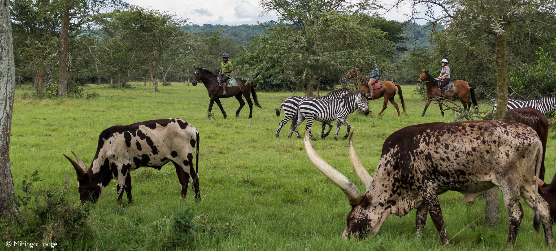
The park is also unfenced, which means that the relationship between the park’s wildlife and the surrounding communities is necessarily ongoing and negotiated rather than fixed and separated. Ankole cattle can still be seen grazing alongside zebras within the park in some areas an image that would have been unthinkable under the conservation philosophy that drove the 1983 evictions, but which today is recognized as a symbol of the reconciliation between conservation goals and community rights that the park is working to achieve.
The local people depend on the park’s natural resources in various practical ways beyond tourism gleaning materials for traditional medicines, thatching, and handicrafts, and benefiting from the fishing that the lakes support. Education support for children in surrounding communities has also become part of the park’s social mandate.
Lake Mburo Today A Conservation Gem With Ongoing Challenges
Visitor Growth and Tourism Development
Lake Mburo’s position as the closest national park to Kampala approximately 228 kilometres from the capital, accessible by road in around three to three and a half hours has made it an increasingly popular destination on Uganda’s safari circuit. In the 2022/2023 fiscal year, the park received 29,881 visitors, reflecting a 30% increase from the prior year and indicating strong post-pandemic recovery. The park serves both as a stand-alone safari destination and as a convenient halfway stop on the long drive between Kampala and the more remote parks of western Uganda, such as Bwindi Impenetrable Forest and Queen Elizabeth National Park.
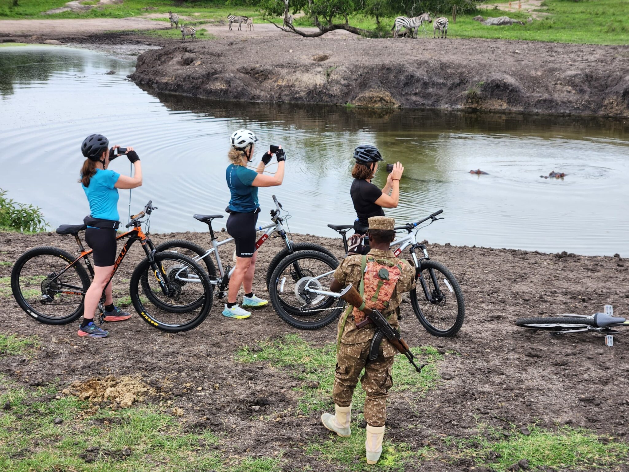
The park offers a uniquely diverse set of activities. It is the only park in Uganda where visitors can observe savanna wildlife on foot, on horseback, by mountain bike, and by boat, as well as in the traditional safari vehicle. This variety reflects both the relatively benign predator profile of the park the absence of lions makes walking safaris safer than in many other East African parks and the progressive management approach that has sought to create accessible, varied experiences for a wide range of visitors.
Habitat Challenges: The Acacia Invasion
Among the ongoing ecological challenges facing the park is the continued expansion of Acacia hockii and associated woodland species into formerly open grassland habitats. This afforestation process, driven by the absence of elephants and exacerbated by historical overgrazing that weakened the grass sward, is gradually reducing the extent of the open savanna on which many of the park’s most iconic species depend.
Park management has explored a range of responses, including different wildfire regimes, community engagement in acacia removal for firewood, potential fencing of key areas, translocation of excess animals, and wildlife ranching for the hunting industry. Community involvement has been encouraged, with local people permitted to uproot acacia for firewood though the impact of this intervention has so far been modest relative to the scale of the problem. The procurement of management equipment and the development of more systematic habitat management plans remain priorities.
The Cultural Heritage Within the Park
Lake Mburo National Park is not merely a wildlife sanctuary it is also a cultural landscape, carrying within its boundaries the accumulated memory of all the peoples who have lived here across the centuries. The sacred site of Rubanga, the Bachwezi settlement at Ruroko, the royal servants’ quarters at Kigarama, the origin story of the lake itself these are all part of what the park protects and interprets for visitors.
The continued presence of Ankole cattle in and around the park, tended by Bahima herders whose culture reaches back generations into the history of this landscape, adds a living dimension to this cultural heritage. When visitors see the extraordinary long-horned Ankole cattle moving through the same grasslands that zebras and impalas inhabit, they are witnessing a relationship between people and land that is genuinely ancient one that predates the national park, predates the game reserve, predates the controlled hunting area, and in some respects predates formal history altogether.